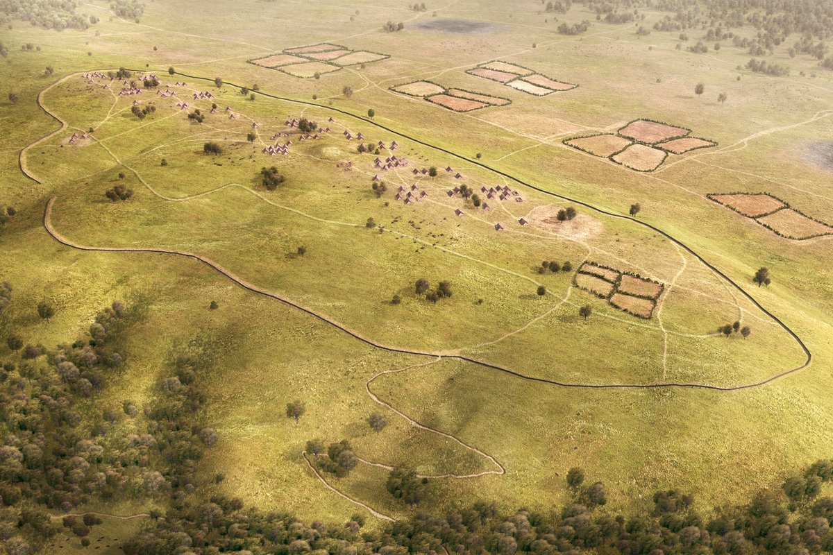
Visualization of the settlement, c. 3700 BCE
 Visualisation of the Kapellenberg, c. 3700 BCE
© Magistrat der Stadt Hofheim, LEIZA, Architectura Virtualis
Visualisation of the Kapellenberg, c. 3700 BCE
© Magistrat der Stadt Hofheim, LEIZA, Architectura Virtualis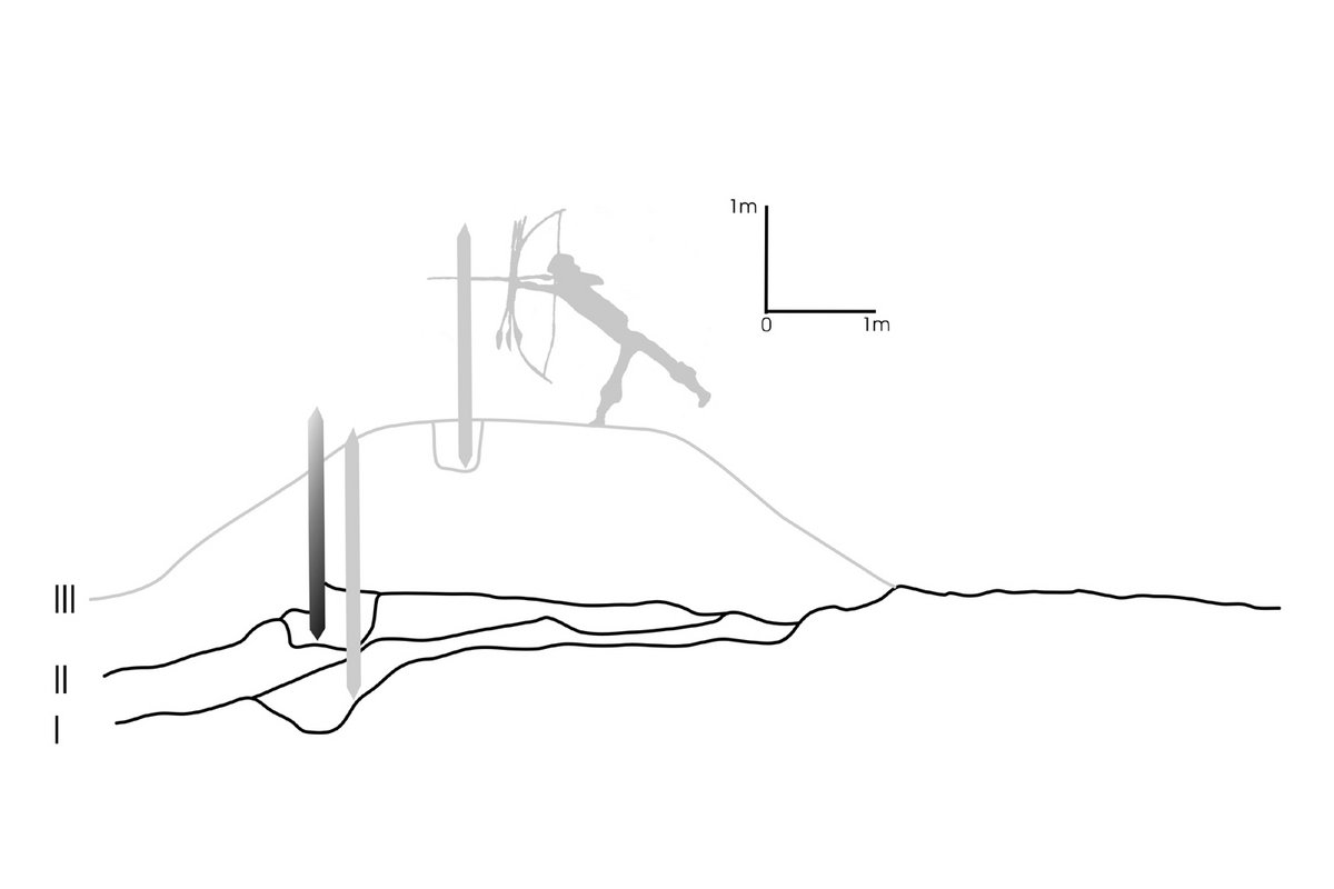 Rampart section from 2012 with reconstruction of the last stage and palisade height
© LEIZA / D. Gronenborn
Rampart section from 2012 with reconstruction of the last stage and palisade height
© LEIZA / D. Gronenborn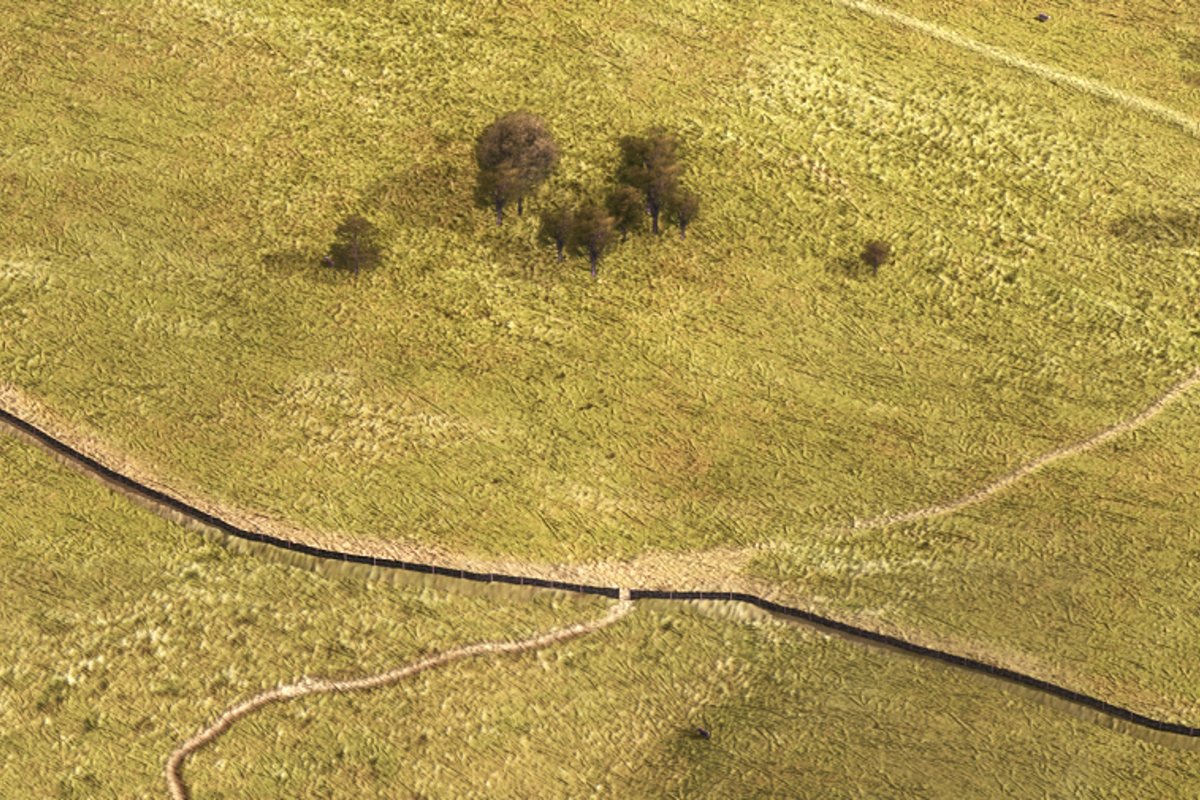 Detail of the visualisation with outer rampart, c. 3700 BCE. Upper right corner shows section of the dilapidated and overgrown inner rampart. The entry is hypothetical here, but documented at another location
© Magistrat der Stadt Hofheim, LEIZA, Architectura Virtualis
Detail of the visualisation with outer rampart, c. 3700 BCE. Upper right corner shows section of the dilapidated and overgrown inner rampart. The entry is hypothetical here, but documented at another location
© Magistrat der Stadt Hofheim, LEIZA, Architectura Virtualis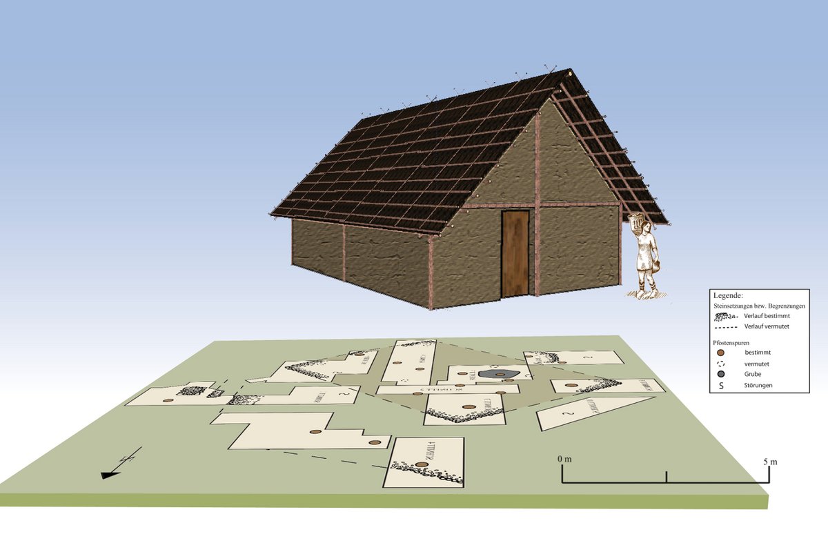 Excavation plan with house features from 1975 and house reconstruction
© Grafik: LEIZA / M. Ober
Excavation plan with house features from 1975 and house reconstruction
© Grafik: LEIZA / M. Ober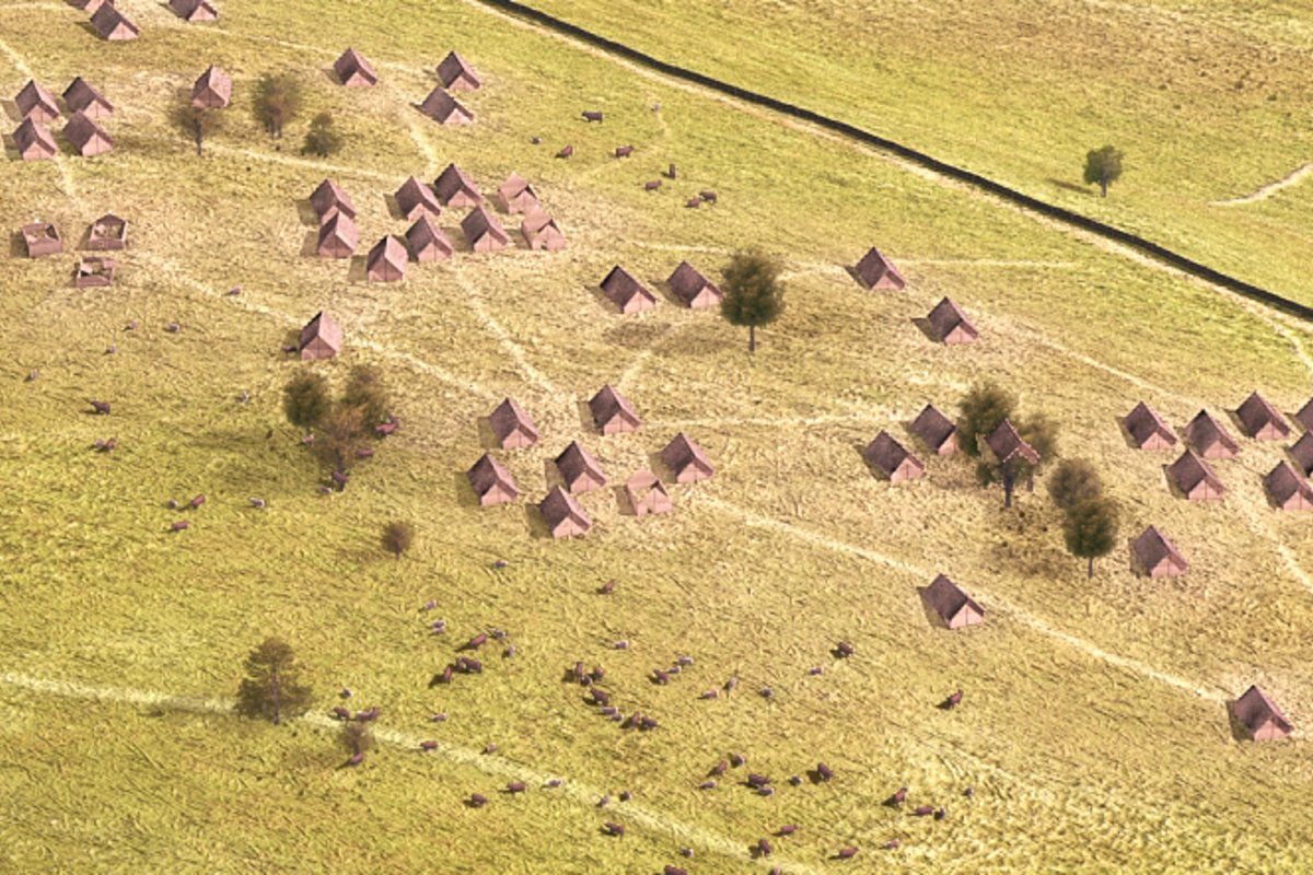 Visualisation detail with view of the interior, c. 3700 BCE.
© Magistrat der Stadt Hofheim, LEIZA, Architectura Virtualis
Visualisation detail with view of the interior, c. 3700 BCE.
© Magistrat der Stadt Hofheim, LEIZA, Architectura Virtualis Visualisation detail with view of the hinterland, c. 3700 BCE. Depicted is the farmland with grazing cattle and traces of slash-and-burn clearing
© Magistrat der Stadt Hofheim, LEIZA, Architectura Virtualis
Visualisation detail with view of the hinterland, c. 3700 BCE. Depicted is the farmland with grazing cattle and traces of slash-and-burn clearing
© Magistrat der Stadt Hofheim, LEIZA, Architectura VirtualisVisualization of the settlement, c. 3700 BCE
The visualisation of the settlement was created in the course of the establishment of the archaeological interpretative path at Kapellenberg. The illustration summarizes the results of the research since 2008 and shows the state of knowledge at the end of 2019 (Fig. 1).
It depicts the period of the largest expansion of the inner settlement between 3750 and 3650 BCE. At this time the inner rampart was already out of use and in some places eroded or it was possibly also partially levelled. It is only at the southern end that it has remained well visible in the terrain until today.
The outer rampart has reached its middle stage of development, but it is not the final stage still visible in the terrain today. This was most likely added at the very end, after the phase visualized here.
Rampart and palisade, c. 3700 BCE
From the 2012 excavation we know quite well how the rampart had looked like around 3700 BCE. On the investigated section we were able to determine the slope and also to recognize that the area immediately behind the rampart was levelled (Fig. 2). In the terrain the levelling can still be seen in some locations. Since it can be seen at different positions along the entire course of the rampart, it is likely that it was once laid out along the entire course of the rampart. Once the material was used for backfilling, but the levelled area also allowed the defenders to change position quickly.
In the profile of the 2012 excavation, a post hole had also been preserved, which provides information about the thickness of the posts. From this, and from the fact that the defenders had to have a view across the palisade, the height of the palisade can be calculated. It is adapted to the representation of a Neolithic archer from Spain. Since the ash layers observed in various places were not very thick, we infer a wattle and daub constructions with posts rather than a continuous palisade of posts standing side by side (Fig. 3).
Houses in the interior
In 1975 Rolf Kubon examined one of the burial mounds. Apart from indications of the structure and construction of the mound, he also found postholes and pits, which he attributed to a presumed pillar construction of the Michelsberg Culture (Fig. 4). With the help of the results of investigations on the construction of houses at contemporaneous settlements along the shore of Lake Constance, a digital reconstruction of the house was made. This and the results of the excavations on the construction of the rampart formed the basis for a GIS-supported reconstruction and visualization of Kapellenberg in the period around 3700 BCE.
Density of interior housing
From the six trenches in the interior, the thirty-year survey by Rolf Kubon, and the geomagnetic surveys by Partick Mertl, but also from the distribution of the 14C-ages, we can arrive at a cautious estimate of the density of the interior buildings and their temporal duration, which has also been incorporated into the visualization (Fig. 5). According to this, the duration is limited to the century between 3750 and 3650 BCE. Michelsberg settlement activities before and after this period cannot be excluded, but may have been minor. The settlement layers excavated so far are not very thick, and features are located several metres apart, so that a loose building density has to be assumed. Possibly houses were grouped with open spaces in between. The maximum population of the village may have been around 900 persons, calculated at an average of 6 individuals per household.
At the beginning of the inner settlement the tumulus was already largely in its present state of decay.
Use of the interior
6000 years ago, the loess cover seems to have been thick enough in some areas to allow the construction of small fields. We therefore assume that the open spaces were either used for the creation of fields or as pasture land, certainly also for the creation of timber areas (e.g. hazel).
Use of the hinterland
The hinterland served to supply the inhabitants and was therefore probably largely free of dense vegetation, especially since trees were also used for the palisades and buildings. The fields were laid out on the eastern loess areas, the grasslands were kept free by slash-and-burn clearing for cattle and cultivation (Fig. 6).
- Copy link
- Print article
Contact
- Prof. Dr. Detlef Gronenborn
- +49 6131 8885-129
- Kontakt